


New Zealand’s night of shakes: What actually happened?
A 7.5 magnitude earthquake struck at 12.02am on November 14 close to Hanmer Springs in North Canterbury. Since then there have been more than 300 aftershocks so far, including a magnitude 6.6. Kaikoura and other North Canterbury towns have been essentially cut off, with State Highway 1 road and rail tunnels blocked by slips. So there is no in and out of Kaikoura unless by helicopters as of now.
Geonet says, “This earthquake was the largest recorded in New Zealand since the M7.8 Dusky Sound earthquake in 2009. But, given its location, it was more widely felt and more damaging. We can say one thing with certainty: there will be more earthquakes to come in this area.”
What happened
Giving details about what happened, Geonet adds, “It looks like we’ve got two separate but related quakes going on. Our reports indicate that the combination of these two quakes lasted two minutes, with the most severe shaking at around 50 seconds. It was widely felt throughout both the North and South Islands. It looks like one was a strike-slip and the other was a thrust fault.”
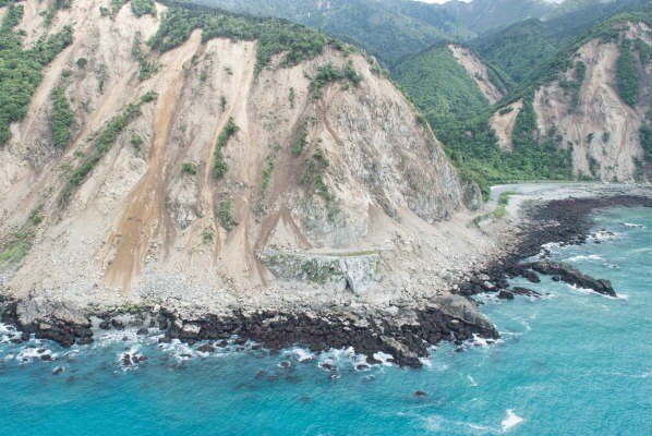
Tsunami and landslides
As regards to the tsunami and landslides damage, Geonet adds, “Our earliest reports are that there is only a little bit of tsunami damage on the coast. Also, early reports indicate that these earthquakes have triggered very large landslides to the north and south of Kaikoura. One was at least 1 million cubic metres. We have three landslide specialists in helicopters now gathering information about the landslides throughout the affected areas.”
Notably, at around 3.15am – almost three hours after the quake, the Christchurch Civil Defence and Emergency Management activated its Emergency Operations Centre. Civil Defence Controller John Mackie instructed people in low-lying coastal areas within one milometre of the Canterbury coast to evacuate inland or head to higher ground. Later by 5am, three evacuation centres were open in Christchurch after the early morning’s earthquake and tsunami alert. These were at Akaroa School Hall, Linwood College (with around 300 people) and Mairehau School (with around 50 people).
By 8.10am, people who were evacuated were allowed to go home.
Surprisingly, and making the matters worse, the Canterbury Police has received around 19 reports of burglars targeting homes in Canterbury after residents fled due to a tsunami warning.
Christchurch situation
Damage in the Christchurch CBD appears to be minimal, although building assessments are still being carried out. The Lyttelton Road Tunnel remains open.
Updates
The Ministry of Education has informed that majority of the schools – 276 of the 524 schools in the affected areas - closed today, will reopen tomorrow. The majority of the Wellington CBD will also be open tomorrow. The slip dam holding back the Clarence River has been breached and water is heading towards downstream at the time of writing the story.
The PM
Prime Minister John Key, who along with Civil Defence Minister Gerry Brownlee, did an aerial survey of the affected area noted that the damage in the Kaikoura region is “worse” than he thought and will “take months to repair”. He also informed that there have been two quake-related fatalities. One in Kaikoura and another in Mt Lyford, north of Canterbury.
Weather
Very heavy rain and potentially damaging winds are forecast to hit the quake-affected areas this evening. “Heavy rain for west of South Island from Monday afternoon and for central and southern North Island high country on Tuesday. Severe gales from Monday evening for Wellington, Marlborough and Wairarapa,” noted MetService.
A 7.5 magnitude earthquake struck at 12.02am on November 14 close to Hanmer Springs in North Canterbury. Since then there have been more than 300 aftershocks so far, including a magnitude 6.6. Kaikoura and other North Canterbury towns have been essentially cut off, with State Highway 1 road and...
A 7.5 magnitude earthquake struck at 12.02am on November 14 close to Hanmer Springs in North Canterbury. Since then there have been more than 300 aftershocks so far, including a magnitude 6.6. Kaikoura and other North Canterbury towns have been essentially cut off, with State Highway 1 road and rail tunnels blocked by slips. So there is no in and out of Kaikoura unless by helicopters as of now.
Geonet says, “This earthquake was the largest recorded in New Zealand since the M7.8 Dusky Sound earthquake in 2009. But, given its location, it was more widely felt and more damaging. We can say one thing with certainty: there will be more earthquakes to come in this area.”
What happened
Giving details about what happened, Geonet adds, “It looks like we’ve got two separate but related quakes going on. Our reports indicate that the combination of these two quakes lasted two minutes, with the most severe shaking at around 50 seconds. It was widely felt throughout both the North and South Islands. It looks like one was a strike-slip and the other was a thrust fault.”
Tsunami and landslides
As regards to the tsunami and landslides damage, Geonet adds, “Our earliest reports are that there is only a little bit of tsunami damage on the coast. Also, early reports indicate that these earthquakes have triggered very large landslides to the north and south of Kaikoura. One was at least 1 million cubic metres. We have three landslide specialists in helicopters now gathering information about the landslides throughout the affected areas.”
Notably, at around 3.15am – almost three hours after the quake, the Christchurch Civil Defence and Emergency Management activated its Emergency Operations Centre. Civil Defence Controller John Mackie instructed people in low-lying coastal areas within one milometre of the Canterbury coast to evacuate inland or head to higher ground. Later by 5am, three evacuation centres were open in Christchurch after the early morning’s earthquake and tsunami alert. These were at Akaroa School Hall, Linwood College (with around 300 people) and Mairehau School (with around 50 people).
By 8.10am, people who were evacuated were allowed to go home.
Surprisingly, and making the matters worse, the Canterbury Police has received around 19 reports of burglars targeting homes in Canterbury after residents fled due to a tsunami warning.
Christchurch situation
Damage in the Christchurch CBD appears to be minimal, although building assessments are still being carried out. The Lyttelton Road Tunnel remains open.
Updates
The Ministry of Education has informed that majority of the schools – 276 of the 524 schools in the affected areas - closed today, will reopen tomorrow. The majority of the Wellington CBD will also be open tomorrow. The slip dam holding back the Clarence River has been breached and water is heading towards downstream at the time of writing the story.
The PM
Prime Minister John Key, who along with Civil Defence Minister Gerry Brownlee, did an aerial survey of the affected area noted that the damage in the Kaikoura region is “worse” than he thought and will “take months to repair”. He also informed that there have been two quake-related fatalities. One in Kaikoura and another in Mt Lyford, north of Canterbury.
Weather
Very heavy rain and potentially damaging winds are forecast to hit the quake-affected areas this evening. “Heavy rain for west of South Island from Monday afternoon and for central and southern North Island high country on Tuesday. Severe gales from Monday evening for Wellington, Marlborough and Wairarapa,” noted MetService.


Related Posts
ISSUE


Leave a Comment